Speaker 1 (00:00):
… the scale of a centimeter on the Earth in a way that we've never been able to see before.
Speaker 2 (00:04):
This is a partnership between NASA and the Indian Space Research Organization.
Speaker 3 (00:11):
NISAR is going to be one of the most sophisticated radar satellites that has ever flown on orbit.
Speaker 4 (00:16):
NISAR is going to open our eyes to seeing the ground in places that otherwise has been obscured.
Speaker 5 (00:22):
NISAR will help us to better understand earthquakes, volcanoes, landslides, floods, wildfires, oil spills.
Speaker 6 (00:31):
The society will also benefit due to its contribution to disaster management and providing food and water security.
Speaker 1 (00:38):
These are global problems that the global community needs to come together to resolve.
Speaker 7 (00:43):
Now it looks like we are no more belonging to two different worlds, and we all belong to the space community. That's it.
Raquel Villanueva (00:55):
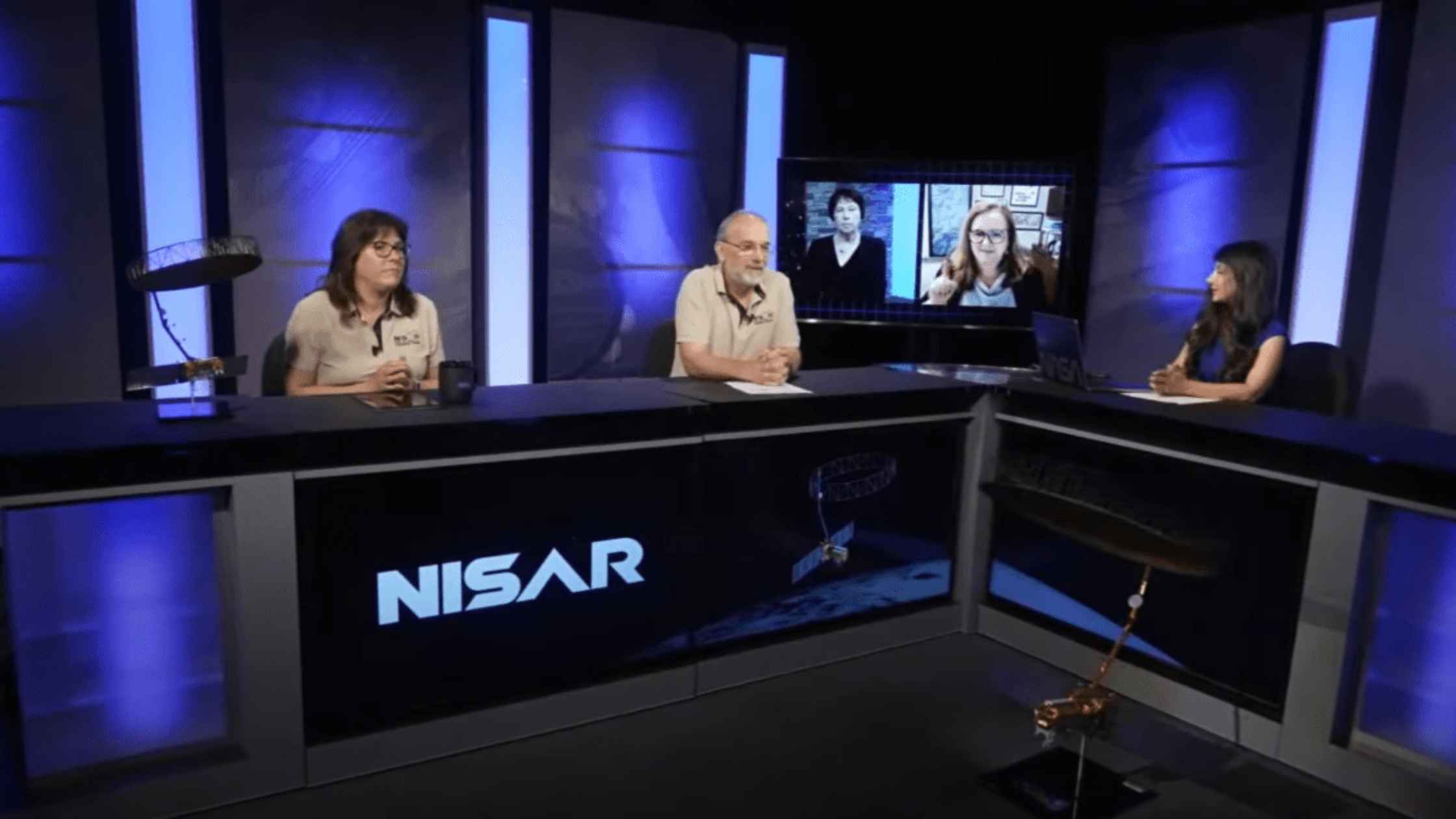
In just a few days, a powerful new satellite will launch to monitor Earth like never before. Hello, and welcome. I'm Raquel Villanueva, coming to you live from NASA's Jet Propulsion Laboratory in Southern California.
(01:11)
NISAR, a collaboration between NASA and the Indian Space Research Organization, also known as ISRO, is the first satellite designed to scan the entire planet using two different radar frequencies. The goal: to help us better understand how Earth's surface is changing.
(01:31)
Now, in case you're wondering what NISAR stands for, it's the NASA-ISRO Synthetic Aperture Radar. But from here on out, we will call it NISAR. Today, we're joined by key members of the NISAR team who will walk us through the mission and how they're preparing for launch, which is targeted for July 30th in Sriharikota, India, from the Satish Dhawan Space Center.
(01:56)
Our panelists today include Nicky Fox, Associate Administrator for NASA's Science Mission Directorate. Karen St. Germain, Director of NASA's Earth Science Division. Wendy Edelstein, NISAR Deputy Project Manager at JPL. And Paul Rosen, NISAR Project Scientist at JPL. If you'd like to ask a question during today's briefing, use the hashtag, Ask NISAR, on social media. And if you're a member of the media on the phone line, press star one to get put in the queue, and to get started, I'll hand it over to Nicky Fox.
Nicky Fox (02:37):
Thank you, Raquel. As always, NASA science is literally everywhere, every second of every day. We do incredible science using the unique vantage point of space. Today, we're extremely excited to tell you about our earth science observations, which we use to deliver life-saving data directly into the hands of decision makers and those who work on the front lines of natural disasters across the globe, ensuring the benefit and safety of all.
(03:07)
Our Earth observing satellite fleet they've gathered data and information about our home planet and our place in it for more than 60 years. And we found that even though we may not always notice it, much of our Earth's land surface is in constant motion. We've seen the devastation and natural disaster, such as an earthquake, landslide, or volcanic eruption, can cause both to the surrounding areas and to people's everyday lives. We especially see this in what is called a slow-moving landslide, where the land appears stable, yet the earth has been moving.
(03:47)
The changes, however, are so subtle that right now they're virtually undetectable. That is before the disaster strikes. The need to be better prepared before, during, and after the challenges caused by natural disasters around the world could not be greater. Now, NASA, in partnership with ISRO, will have the opportunity to do the precise science needed to zero in on these topographical movements.
(04:18)
In the coming days, we will launch the first-ever mission between the United States and India to observe our home planet like no mission has done before. NISAR truly is a first-of-its-kind dual radar satellite that will change the way we study our home planet and better predict a natural disaster before it strikes. NISAR will scan and take imagery of nearly all the Earth's land and ice surface twice every 12 days in unprecedented detail, literally down to a centimeter. It will peer through foliage, study building footprints, measure flood depth, and so much more.
(05:02)
NASA's observations will assist decision makers across the globe in disaster monitoring, mitigation response, and recovery. You will hear more from the panel on how NISAR will do all of this and all kinds of really exciting details. But I will end with the thought that NASA's data is open to everyone, and it will be filtered into the resources that are easy to understand by decision makers and responders alike, so getting that critical data into the hands of people that need it. Where moments are most critical, NISAR's data will help ensure the health and safety of those impacted on Earth as well as the infrastructure that supports them.
(05:46)
We are so excited to partner with ISRO for the first time ever on a NASA science mission. So, go NISAR. Now, over to Karen St. Germain, our amazing Earth Science Division Director.
Karen St. Germain (06:01):
Thank you so much, Nicky, and I am also excited to be here. Let me talk a little bit about how NISAR fits into our earth science efforts. NASA studies the Earth as a system, and today we have more than two dozen missions in orbit studying our oceans, land, ice, atmosphere, and life on our home planet. Some of those satellites are generalists and some are specialists in what they observe, and each mission has great value on its own, but we get a far greater understanding of how the earth works when we can look at these missions together, because together we can observe how a change in one aspect of the earth may drive changes in other aspects. Even small and subtle changes can mean significant differences across the entire Earth system. NISAR will launch on the morning of Wednesday, July 30th, and this science mission will advance our understanding of the Earth system with cutting-edge technology, capable of studying changes in land and ice, changes as small as a centimeter in any weather, and in both darkness and light. So, let's talk about why this is important. It's important because we know, we understand that our planet's surface undergoes constant and meaningful change. These include natural hazards such as earthquakes, landslides, and volcanoes, land subsidence and swelling, movement, deformation, and melting of mountain glaciers and the ice sheets that cover both Greenland and Antarctica, and of course, wildfires.
(07:53)
We also see human-induced changes such as farm and ranch production, use of water for municipal drinking and farm irrigation, infrastructure and land development, houses, commercial buildings, railroads, highways, and bridges. We'll put NISAR science and observations to work, making it available to inform decisions, where and when they're needed, helping to ensure that as a nation we can abundantly feed ourselves, build resilient housing and transportation systems, and better prepare and respond to natural hazards.
(08:32)
More than 180 organizations from local public agencies to research institutions and private sector companies are already looking to use NISAR science and data. These early adopters will use NISAR information to support disaster response and recovery, map forests and forest covered density in as small as a soccer field, track and manage groundwater supplies, monitor fire risk, track seasonal, annual and long-term trends in wetland flooding, and measure coastal vegetation to help communities and people who live along the water's edge, manage storm surges and other fluctuating coastal conditions.
(09:18)
I'm proud to highlight NISAR as a terrific example of NASA's unique end-to-end capability, from innovative technology to research and modeling, to delivering science to help inform decisions. And as an international partnership built upon open science principles, NISAR is also a model for the next generation of Earth observation capabilities. Finally, I want to recognize the leadership of ISRO and NASA's JPL teams. The collaboration, cooperation, and information sharing between our two agencies is a foundation that we really look forward to continuing to build upon. So, go NASA, go NISAR. And now I'd like to introduce NISAR's Deputy Project Manager, Wendy Edelstein. Wendy?
Wendy Edelstein (10:08):
Hi. Thank you, Karen. It's great to be here to give an update on the NISAR mission, and I'm happy to report that the satellite is fully built, it's tested, and it's ready for its ride into space and our team can't wait. So, right now the NISAR satellite is in India in its final preparations for launch, coming up on July 30th. I wanted to orient you to what NISAR is before we get too far along. So, over here is a one-third scale model of what NISAR will look like when it's on orbit. What you see here is the spacecraft bus is this square cube over here on the right, and that's what provides all the services to operate the satellite. These solar array panels are attached to the spacecraft bus, and that's for powering the system. Now, this octagonal gold structure, that's what houses the two radar systems, and I'll talk more about those in a moment. But the radars are then used to illuminate this very large antenna you see here, and that's probably the most prominent feature of the NISAR satellite.
(11:15)
This large antenna, when fully deployed, is 12 meters or about 40 feet in length in diameter, which is about the size of a school bus. So, it's fairly long. And when it's fully deployed, it's about the size of half a tennis court. The surface material here it's made of a lightweight mesh material, so it allows the whole antenna to fold very compactly, and it can be stowed for launch.
(11:43)
So, NYSAR is an equal 50/50 partnership between NASA and ISRO. It represents the largest collaboration in space between the United States and India. And so to give you some… Since it's such a unique partnership, I wanted to highlight some of the contributions of each agency.
(12:07)
So, can you show my first chart?
(12:10)
So, at the heart of the NISAR satellite is the two radars which make up the science instrument. Each radar targets different science, and that's based on its operating frequency. The L-band radar, which is provided by JPL, operates at a longer wavelength and that can see through the trees and see the bare surface of the bare earth and even some substructure. The S-band radar, which is provided by ISRO, operates at a shorter wavelength and that sees the vegetation, foliage, surface features better. Together, these two radars work together, complementary to achieve science that neither could see on their own.
(12:52)
Now, both of these radars share that large antenna I just talked about, and it's Boom, and that's provided by JPL. ISRO, in addition to the S-band radar that they have built, also built the spacecraft bus, the solar arrays, and ISRO is also providing the launch vehicle and launch services.
(13:14)
So, I often get asked, "What is it like working with India?" And I have to say, one of the challenges of NISAR is working with an international partner that's 9,000 miles away, literally on the other side of the world. With ISRO 13 time zones away, that means a lot of early morning and late evening telecoms, and it also means a lot of long-distance travel to India. In fact, it takes 36 hours door to door to get to Bangalore, India where the system was being tested. I personally have been to India over 25 times over the past 10 years, and in the past two years alone, I've spent over 150 days working side by side with our Indian colleagues, building this system and working as a team together. I also have learned and been fully immersed in the Indian culture, and it's been a very big highlight for me personally.
(14:10)
Now, a satellite, the size and complexity of NISAR, requires a lot of testing both in the US and in India. And we've been testing this system for the past five years. So, I'm going to show a short video that shows our journey through our testing at JPL.
(14:27)
Go ahead and roll that.
(14:28)
So, here's where the S- band radar was delivered in July, early 2021, and it was integrated with the L-band radar. We installed the Boom and the reflector, as you can see there. We went through a series of tests including thermal vacuum, vibration testing showed here, and then we deployed the Boom, and then we deployed the reflector. And here you can get a real good idea of just how big that antenna is. Once it was fully built, tested, we then stowed it for launch and made sure it was ready for our ship to India.
(15:06)
So, then we prepped, we packed and prepped up the system to take to India. We transported it to the March Air Base Reserve in Riverside, California, and then we put it on a massive C17 military aircraft as shown here, so it would make its 9,000-mile ride to India. So, the radar arrived in India in March of 2023, and at that point, we started our integration with the spacecraft.
(15:38)
So, go ahead and show my next slide.
(15:41)
Okay, so here's a picture of the happy JPL and ISRO teams testing the system and the beautiful facilities at ISRO. On the right, you see the instrument system, and on the left is the spacecraft. In my next video, you'll see an important
Wendy Edelstein (16:01):
One of our final tests in a special facility called an anechoic chamber. And what that means is it's a very quiet room that allows all the systems to work as they would on orbit to make sure there's no interference or noise that could cause any degradation in the performance of the mission. And this is a really important test to make sure that everything works as expected. So go ahead and show my last picture. So all of the system testing is now complete. We've now shipped the NISAR satellite to the launch site in May and the launch site in Sriharikota, which is on the east coast of Southern India.
(16:41)
We've completed all the system checkouts, the rocket's fueled, and as you can see here, it's been fully encapsulated in the launch vehicle fairing and we're ready to launch on July 30th. And on a personal note, I just want to say I've spent my entire career working on radar missions for JPL and NISAR is the highlight for me. I can't wait to see the science it produces and the impacts it has both on real world applications and the societal impacts. So I think it'll help people around the world. And to hear more about the exciting, amazing science, I'm going to hand it over to Paul Rosen, the project scientist. Go NISAR.
Paul Rosen (17:20):
Thank you Wendy. It's great to be here. You've heard a lot about the science and applications actually from the other panelists. So I'm going to focus on NISAR's ability to do these things, the methods that we're going to do this. Providing new insights into Earth's changing surface in ways we've never seen before. So remote sensing missions like NISAR are storytellers, I would say, about Earth and how humans interact and connect with the planet with all its beauty and abundance and dangers. And NISAR is a truly great and unique storyteller because of the fact that it's a radar. We provide reliable data, all weather sampling of the Earth day and night.
(18:03)
And we're doing this every 12 days over all land and ice coverage surfaces of the Earth. So we sort of build up a movie frame by frame of every point on the Earth's surface. And we don't have any frames that are missing because of the reliability of the radar data such that we get this sort of all the action in the movie that we can see. So NISAR provides very fine resolution for a radar, and we do that using a somewhat magical technique called synthetic aperture radar. If you could cue the animation to show what this looks like. So here you can see the radar is flying along its orbit track in the top left. We send out pulses of energy from the radar.
(18:43)
Given the size of the aperture, the antenna, and the wavelength, we have a very large footprint on the ground. So if we were to just use those pulse echoes coming back all by themselves individually, we would get a very blurry picture of the earth. But because we are pulsing over a thousand times per second, we can collect those radar echoes as we're flying along and create an antenna as though it's 10 kilometers in length or 10 miles in length. And that gives us very fine resolution, as you can see, building up in the top right corner. So this synthetic aperture radar techniques gives us the resolution, a high definition movie of the Earth, so to speak.
(19:28)
NISAR also provides 2D motion in its movies. So if you could queue the next animation, you saw this a little bit earlier, but I'll say a little bit more detail about it. We fly in an exact repeat orbit and use another technique called radar interferometry where we fly along, collect the echoes, make the image, come back again at a later time and make another image and use the radar as a yardstick basically. We count the peaks and troughs of the radar waves and use it as a yardstick to be able to measure how the ground is moving over time. This animation is over the Central Valley of California and we can see feet worth of subsidence due to groundwater withdrawal in this area.
(20:16)
We have precision down to millimeters and centimeters using this radar interferometry technique. So that gives us 3D motion for looking at volcanic deformation, tectonic plate motion, land subsidence as you see here, and anything that's moving at the scale of a centimeter or so. NISAR also sees the earth in a fundamentally different way than optical systems and many other systems. So if you could queue the next graphic. We see in the part of the spectrum that's invisible, it's above the red. If you think of the rainbow as all the different colors of the spectrum we're somewhat above red. So over the rainbow. And by virtue of this, we are not susceptible to clouds and we see very different things.
(21:05)
We see the electrical properties and the structural properties of the surface. So in this graphic on the left, you can see an optical image from Landsat, another NASA satellite in partnership with USGS. First thing you see is it's a little bit hazy because of the cloud cover that we can see at visible frequencies. You can also see a river, and there's rainforest below in this area of Peru called Pacaya Samaria. On the right however, what you're seeing now is the radar image from an airborne system that we sent down there. Airborne radar at the same wavelength as NISAR. And what you see is a very different picture. You see the greenish colors are rainforest and the pink and reddish colors are flooded forests.
(21:52)
So we're actually penetrating through the canopy and reflecting off the trunks and the water below the surface below the canopy to give us a very clear picture of what's flooded and what isn't flooded. The black area of the river, of course, is actual open water. So this gives us a very distinct view, and by virtue of the fact that we have two radars at two different wavelengths, such as we have an S-band, the shorter wavelength an L-band, the longer wavelength, we increase our sensitivity to the ability to see different kinds of vegetation. We can see smaller vegetation, we can see larger vegetation. It's very important for agricultural monitoring and food sustainability studies.
(22:36)
So the story that we can tell on many different fronts from cryosphere, from ice sheets and sea ice changes, from forest degradation agriculture, and all kinds of hazards around the world using our interferometric measurements. It's just quite astounding and I'm really looking forward to this. I've been working on this mission for I guess three years to get it going and in partnership with NASA headquarters, ISRO, and the broader science community, I can tell you the excitement about NISAR is just growing daily as we get ready for our July 30th launch. Thank you. And back to you, Raquel.
Raquel Villanueva (23:18):
Thank you so much Paul. So we are now ready to take your questions. Again, if you are media on the phone line, press star one to get put in the queue and please direct to a speaker if possible. And you can also keep those questions coming using the hashtag askNISAR. So first on the phone line, we have Marcia Dunn with the Associated Press.
Marcia Dunn (23:42):
Yes, hi. Probably for you, Nikki, the cause question, if I might, what is NASA's contribution to the mission? I've seen online references to one and a half billion dollars total for both countries, but is that accurate as well? And I just wondered how unique is the antenna reflector? It looks a little different than any other I've seen. So what can you tell me about what makes it different? Why is it so big? Why not have more of a traditional type reflector? Thanks.
Nikki (24:16):
Thanks so much Marcia. So the NASA budget for NISAR is 1.2 billion. As Wendy said, it's roughly a 50/50 with ISRO, but I will defer to them on their final costs. We'll follow up with you on that. And the dish is unusual. It's not totally unusual. We've flown that kind of sort of blooming antenna before, but it is just an unprecedented amount of detail that we're able to look at with NISAR. And I'm actually going to toss to Karen because I know that she would love to gush about the excitement of this radar antenna. So Karen, over to you.
Karen St. Germain (24:58):
Thank you Nikki. And let me just amplify the excitement about flying an antenna this large. And you saw a great animation from Paul on why fly an antenna this large? Well, to get that spatial resolution, to get that high fidelity view of these what can be very small changes, but they can have enormous implications. So we're really excited. And I will tell you, I'll echo something that I think Wendy said. It's really something when you see that antenna deployed.
Paul Rosen (25:39):
I could add something.
Raquel Villanueva (25:41):
All right, Paul and Wendy, if you'd like to add as well. Go, Paul.
Paul Rosen (25:44):
One reason for the large size of the reflector is just to be able to collect as much light as possible to increase the sensitivity. It's kind of like a bucket to collect rain. The larger the bucket, the more rain you can collect. So we want to collect as much light as possible. The antenna itself is a heritage design. It's been flown many times in geo for telecommunication satellites. So we're quite confident in its ability and its heritage.
Wendy Edelstein (26:15):
And I just want to also point out one reason why we use this type of reflector antenna as opposed to a phased array antenna sometimes is because of the dual frequency system. They both have a feed right here that illuminates this large antenna. So without having to enable this partnership is why we need to have this kind of a reflector antenna. And again, as Paul said, the size is driven by a combination of resolution and coverage. So it's required for all of that. Thank you.
Raquel Villanueva (26:47):
All right. Thank you all for those answers. And up next we have Will Robinson-Smith from Spaceflight Now.
Will Robinson-Smith (26:54):
Hi, thanks so much for taking the time to talk with us today. Question either to Karen or Wendy, I suppose. Can you talk about the deployment timeline once the satellite has separated from the rocket's upper stage, how soon you expect to acquire signal, what the deployment timeline is for the boom and for the reflector? Thanks.
Karen St. Germain (27:19):
I'm going to hand that question over to Wendy.
Wendy Edelstein (27:22):
So we will launch on July 30th. Within a few days we will get the whole spacecraft checked out and operational. We'll get our acquisition to signal. And on day 10 of the mission is when we start the deployment process of both the boom and reflector. And it takes eight days to deploy it. There's four hinges on this boom. So every day each boom is deployed. And then on the last day of our deployment is when we deploy the full reflector. And that's a two-step process where we first bloom it to partially deploy it and then we power deploy it to the full opening. So again, it's an eight-day process to complete the full deployment.
Raquel Villanueva (28:08):
Great, thank you. And then up next on the phone line, we have Alexandra Witze from Nature Magazine.
Alexandra Witze (28:15):
Hi, thanks for taking my question. This is for Karen St. Germain. I want to ask about the future, and I'm going to try to thread this in a way that you can answer. You've talked about how NASA Earth science missions work together to strengthen our understanding of the Earth's system. Can I ask you to just look in the future a bit more along those lines, how do you see NISAR working with the Earth science fleet that you currently have at NASA? How long do you see it continuing to work and how might it inform future NASA Earth science missions if we have those?
Karen St. Germain (28:49):
Thanks. That's a great question. And this will be the first time that we have a capability like NISAR on orbit. And so you've heard us talk about the things that we already know it will be able to see. One thing for sure, one thing we've learned over and over again about missions that look down at the earth is we will learn things and see things that we didn't ever expect to see or didn't anticipate seeing. So there's always a lot of serendipity that comes along with these first-ever missions. But I will say that it does fill a very different role. And actually the image that we just saw comparing electro-optical to SAR imagery that Paul showed. That actually gives you a good sense of how a radar mission sees the Earth very differently from electro-optical, from thermal, from gravity missions, and so forth.
(29:59)
So when we look at how the earth is changing and it is always changing, NISAR will give us positional change, movement structure that has changed. And that's a really important independent piece of information which can be combined with what we learned from other missions. And this kind of knowledge has been reaffirmed well in the 2007 decadal survey and in the 2018 decadal survey. They reaffirmed the importance of this kind of information. So NISAR will be a pathfinder for us in many ways and lead us into the future. Help us understand how we might define and build future follow-on synthetic aperture missions.
Raquel Villanueva (30:56):
Thank you, Karen. And up next we have some social media questions, but just a reminder, if you're a member of the media, press star one to get put in the queue. So up next we have a question from Jeff Foust of SpaceNews who asks on X. There we go. How has NASA ensured that recent anomalies on ISRO missions like the NVS-O2 spacecraft and PSLV-C61 launch do not pose a risk to the NISAR launch? Nikki.
Nikki (31:29):
Thanks for that question. As always, we like ISRO to answer any questions about their launch vehicles, but obviously we've been getting a lot of data from them and we just can't wait to see NISAR take to the skies on July 30th.
Raquel Villanueva (31:47):
Thank you, Nikki. Up next, we have Manish on YouTube who wants to know what kinds of natural or human-driven processes can NISAR detect that existing satellites cannot? Paul.
Paul Rosen (00:00):
Paul Rosen (32:00):
So as Karen said, we're not entirely sure what we can detect. We designed the mission to meet a set of measurement requirements that are based on what we know. What I can tell you is that because of the regular repeated acquisition, the reliable data, the time duration of the measurement, and the spatial and temporal resolution combined, we expect to improve the accuracy and therefore the predictive capability of all of the science topics that you've heard about today by an order of magnitude. I think there's going to be serendipity, there's going to be discovery, but the scientists have designed this to give them a better handle on how the earth is changing for the things that they already know.
Raquel Villanueva (32:56):
Thank you, Paul. We have someone else on the phone line now. It's Kenneth Chang from the New York Times.
Kenneth Chang (33:03):
All right. Excuse me. Thank you. I was wondering if you could give a bit of a back story of how NASA came about. This is a big, expensive, ambitious project, and how this ended up being the first mission that you do for the first time with a space agency you haven't worked before. I was also wondering why is ISRO not participating in the news conference at all? You don't have anyone there, you don't have anyone remotely. You don't even have a recorded message from anyone at ISRO. Thank you.
Raquel Villanueva (33:35):
Nikki, Karen?
Nikki (33:39):
Karen, go ahead.
Karen St. Germain (33:41):
Okay. Well, I think I'll start with the last question. We coordinate very closely with ISRO. The answer to the participation question is simply the time zone difference, but rest assured, we are working very, very closely. On the story of NISAR, actually, I think I want to turn over to Paul because he has been tracking this story from the very beginning. So why don't you go ahead and tell the story, Paul?
Paul Rosen (34:12):
Sure. Well, how much time do we have? Back in 1992… No. I think the short answer is because of the 2007 decadal survey, which recommended a synthetic aperture radar-based mission that could service a number of different science disciplines that are now present in NISAR, ecosystem science, cryosphere science, solid earth science, it actually recommended a radar plus a LiDAR mission at that time. We've been studying it, trying to come up with something that's cost-effective and capable that meets the requirements that were outlined in the decadal survey, which as Karen said, were also reaffirmed in the 2017 decadal survey.
(34:59)
So in the early days we were working with various international partners to make sure that we could, again, afford this mission. It's difficult programmatically to get an international partner who has the same kinds of objectives that you have that align in time with your own programs. We went to various countries, Germany, Canada, Argentina, and it wasn't until 2011, when NASA decided that the LiDAR could go off in a different direction and we stick with just the radar, that actually I was sent to India to tell them about this mission concept.
(35:45)
India said, "This is exactly the kind of thing we would like to do next. We need to have a technology element to it." Because we already had this reflector feed design in the back of our minds as one of the trade options, somebody, like maybe me, suggested we could put two radars on this and they could build one and we could build the other. They really resonated with that and that's what formed NISAR. It took a few years to get the partnership going. I think President Obama and Prime Minister Modi met in around 2014, and that's when the deal was sealed and after that we've been developing it.
Raquel Villanueva (36:36):
Thank you for that story, Paul. Oh, Karen?
Karen St. Germain (36:40):
I was just going to add a little bit because I joined the NASA team in 2020 right at the beginning of the global pandemic. I just want to acknowledge Wendy gave a hint as to how much time she has spent traveling back and forth to India, and that is representative of the work that the JPL engineering team did as well as the ISRO team. Doing that kind of collaborative work through a global pandemic was an extraordinary challenge and I just wanted to take the opportunity to congratulate the team on driving progress forward on this mission throughout those challenges.
Raquel Villanueva (37:32):
Thank you so much for that. We also have some social media questions coming in. I think this one is for you, Karen, too. Rythen on X wants to know, "How will the NISAR satellite help in predicting natural disasters like earthquakes and landslides?"
Karen St. Germain (37:50):
Yeah, so I'm going to take a shot at this and then I'll hand it over to Paul to further develop the answer. To me the idea is that we will be able to see very small motion, very small changes in position, and often these kinds of changes are precursors to larger events. That's particularly true for things like earthquakes and landslides and volcanoes. So we really think that having these very accurate early measurements will help us see events in their very early stages and also help us improve our models that can predict such events. But I'm going to hand it over to Paul, who's the real expert on this.
Paul Rosen (38:41):
Well, that's perfectly correct what you said. I'll just add that in addition to the displacement or deformation measurements that we will make throughout the course of the mission, therefore we can see what's moving before an event happens, we also are measuring through these two frequencies, L and S-band, we're measuring soil moisture. The soil moisture has a big impact on landslide susceptibility also. So by tracking changes in soil moisture, we should be able to also feed that into our models for understanding when land may move.
(39:25)
Another point on earthquakes, one thing that we also have learned over the years from airborne and other anecdotal data is that the earth is moving in ways that are not always expected. There are many faults, for example in California and other places around the world, that are actually always creeping very slowly and imperceptibly, unless you have a radar, that may be relieving stress on some of these faults and therefore giving us a hint that the earthquake potential may be less in certain places than we had previously thought.
(40:02)
So these measurements will help modeling and predictive capability in every sense. For the cryosphere, where we're measuring ice sheets and sea ice change, the mechanics of ice, the many kilometers thick ice as it flows into the oceans, it's not fully understood. The interface between the ice and the bedrock below it, how lubricated it is, that's also not well known. These things by measuring the velocity that we get from the deformation measurements, that helps us with the modeling of the entire system, which will help us with predictive capabilities there as well.
Raquel Villanueva (40:49):
Thank you, Paul. Just a reminder to members of the media, press star one to get put in the queue. We actually have a couple follow-up questions, starting with Alexandra Witze from Nature Magazine.
Alexandra Witze (41:02):
Hello again. I have a couple of data questions for Paul Rosen. I wanted to ask what the pace of discoveries, like when do we first start to get data after all the deployments, like when will the first science products start coming down? Then just to follow up on some of the discussions about open science, is all the data from all the instruments, including the ISOR contributions, also going to be openly available?
Paul Rosen (41:29):
So that's an easy one to answer, the last question. The answer is yes, all the data will be available. The L-band data from the NASA instrument will be at the Alaska satellite facility in its entirety. We have an unprecedented data set for NISAR compared to any other SAR mission. We're not just producing radar images, but we're producing various derived products from it, from interferograms and polarimetric products in a geocoded map format that should make it very easy for scientists to just take the data and use it.
(42:09)
The S-band data from the ISRO instrument, that will be hosted at their own site, it's called Bhoonidhi, at the National Remote Sensing Center in Hyderabad. They are redoing their entire distribution system to be very similar to ours. ASF is wonderful for making data available conveniently, and we expect the S-band data for NISAR also to be the same in India.
(42:41)
So in terms of availability of the data, we have around let's say 65 days of various engineering-related activities, including getting the satellite into its final science repeat orbit and then calibrating the pointing and other aspects of the radar. So by day 65, we expect to get the first full-frame science grade images. It still won't be fully calibrated and we won't be in our operational mode yet, we'll just be taking data in various places just to check it out.
(43:18)
Those data, once at the level of satisfaction of the science team that they are distributable, will be made available too, but it's not until around day 70 when we start ramping up to this science phase. We actually begin the science phase after day 90. The commissioning period is 90 days. That's when we officially will be taking data at the pace of all land and ice-covered surfaces twice every 12 days. From day 70 on, assuming that the quality meets our standard, all of those data should be freely available from the ASF DAAC. I have championed the position that we don't want to hold on to any of these data, so the community can get to it right away.
Raquel Villanueva (44:11):
Thank you, Paul. Up next we have Marcia Dunn from the Associated Press with a follow-up.
Marcia Dunn (44:18):
Yes, a question for you again, Paul, if I might. Everyone's mind is so tuned right now to the terrible, tragic flooding in Texas of late with so many killed. How could this mission have prevented that or perhaps something like that in the future? How much can NISAR help with this flooding issue that can be so deadly at times? Thanks.
Paul Rosen (44:47):
Okay, so we can provide information, that's what NISAR is good at. We can provide several pieces of information. One is, as I mentioned, soil moisture. By understanding the soil moisture environment regionally, one can use that to understand the susceptibility in large rainstorms for flooding. That's one thing. The other thing is deformation. Over the life of the mission, as we measure changes in the land surface, assuming there is any, we can see how the floodplain is changing and also will give us a sense for the susceptibility of floods.
(45:28)
After an event like this occurs, we will be making observations twice every 12 days at the latitudes of the U.S. That means that 77% of the time or so we can see a given spot on the earth every four days or so. So that means that for floods, which are very fast moving, we can't give immediate response. But with NISAR, in combination with other international satellites, you can begin to build up an ability to see disasters as they unfold in a very rapid pace, and that should help with identifying areas of concern for first responders. We know that for earthquakes and volcanic eruptions in the past radar data have proven very helpful, even with a longer cadence for first responders to understand hot spots and where to deploy.
Raquel Villanueva (46:28):
Thank you, Paul. Karen?
Karen St. Germain (46:30):
Can I just augment?
Raquel Villanueva (46:30):
Yes.
Karen St. Germain (46:30):
Yeah, I'd just like to augment. That was a terrific answer, Paul, and I just want to just add a layer of information around that, which is just to be very clear, of course, NASA is a science exploration agency and there are federal and state level operational agencies that have that responsibility for delivering those operational services such as warnings and alerts. So everything Paul said is absolutely accurate and can contribute to those efforts. We can improve our situational awareness and our predictive models and transfer that information and understanding to those operational partners and support them in their efforts.
Raquel Villanueva (47:28):
Thank you both for your answers. We also have Will Robinson-Smith from Spaceflight Now on the line again.
Will Robinson-Smith (47:37):
Hey, thanks for allowing a follow-up. Maybe just picking up where this conversation just left off with Karen and Paul, as far as the data is presented and available to folks, can you talk more about in what form that will take, like what people will be able to see when trying to access the data? For any particular region that's
Will Robinson-Smith (48:00):
… and wanting proponents of data on just their specific neck of the world. Is there a way to sort of stack up multiple revisits and create a visual timeline for analyzing certain aspects of the data that's going to be presented for just say, Dallas, Texas, or just [inaudible 00:00:24[ example.
Paul Rosen (48:23):
So I'm not entirely sure I know what you're driving at, but I can tell you about data access and what the products are. So we have a variety of products, images that are complex radar images. Each image is roughly 240 kilometer by 240 kilometer frame, and these frames are everywhere around the world. And they are in a time series, and everyone is uniquely tagged. In addition to the images, there are derived products. These are interferograms, which are 12 day separated images combined to make a displacement measurement, which is coded in the phase of the measurement. Those are also geocoded so that you can immediately compare those to any other kind of map product.
(49:23)
We also create something called the covariance product, which is basically the polarization information for the various channels of the radar that are also geocoded and corrected for terrain slope effects. So a directly usable analysis-ready data product. So there's a suite of something like 9 to 15 products depending on the region of the world for each frame.
(49:51)
Those are at the ASF DAC, the archive center and distribution center. There is a web interface that allows you to draw a box any place on the world that you want, discover what data sets are there, using a set of attributes about the radar, the frequency, the polarization, the resolution, that kind of thing, lots of selections. That will then deliver to you a list of all the products available. And then, you can either download them through a very simple API interface. You could also do this not through the web, but through an API. You could either download them for your own analysis or you can use them on the cloud through various cloud resources that NASA makes available and that, of course, other cloud providers do as well.
(50:44)
So it's very easy access. It's almost all the products except for the raw radar data, those are all analysis ready to be used in a variety of algorithms. I would say that for the science products, the science requirements that we are validating, the science team has put together a set of algorithms and code that is also freely available, and you should be able to get that code if you're so interested, get the data that in a time series fashion, feed that to the code and reproduce the results that the science team is doing for validating. And that code then should also be applicable anyplace around the world. So we're providing at least the basic tools for scientists and applications developers to go at it with these data.
Karen St. Germain (51:46):
And if I could amplify that just a little bit. So Paul just gave a great description of all of the ways that folks can access data, particularly for scientific purposes and so forth. Let me move all the way to how would we support a first responder? Because a first responder or an emergency management organization is not in the heat of the moment going to be able to make use of raw data. For that, we work through our applied science work and with early adopters to build tailored products to co-develop generally tailored products to provide the kind of information they know they're going to need in an emergency. So Paul had given an example earlier of flooded agriculture land versus flooded built environments, neighborhoods. Distinguishing those kinds of attributes in easy-to-read maps is the sort of thing that we would work with these operational agencies with in advance, so we have them ready to go when they are needed.
Raquel Villanueva (53:12):
Thank you both for that answer. And we have some more social media questions coming in. So this one looks like it is for you, Wendy. Tanya on YouTube wants to know why was something as large as a tennis court needed for NISAR in an age where devices are getting smaller and more compact?
Wendy Edelstein (53:30):
Right. So yeah. So one thing that doesn't change is the laws of physics. And in order to get the resolution that we need for NISAR, it needs a large aperture. I think Paul mentioned that the more you can illuminate it, the more precision you can have in a measurement. So we just see the very large antenna aperture. Everything else has been shrunk down somewhat, but the antenna size is kind of driven by the resolution requirements of the system. In addition to that, we also have other requirements for global coverage. And so, other aspects of this design require us to scan our antenna beam using this big antenna. Again, that's to give us this large swath coverage to get our 12-day repeat. Thank you.
Raquel Villanueva (54:15):
Do you want to add some more?
Paul Rosen (54:18):
There's plenty of small-scale shrunken electronics on this thing. In fact, you can think of this as 24 individual radars at one frequency and 48 individual radars at the other frequency that are all combined together using sophisticated processing techniques to create this one or two radar system. So we do take advantage of modern technology, but we do need a big aperture.
Raquel Villanueva (54:51):
Great question about the design. We have another social question coming in from Matthew Henson on YouTube who wants to know, will it be scanning the wildfires of California and Canada and the rest of the Western United States?
Paul Rosen (55:07):
For me?
Raquel Villanueva (55:08):
For you or Karen.
Paul Rosen (55:10):
We're scanning everything. Every 12 days, twice, we will cover everything. And radar is very good at detecting changes in vegetation cover. So from before to after a wildfire, we can see very clearly where the fire scars are. Of course, with the 12-day repeat and with the speed with which wildfires move, it's very difficult for one satellite of any sort to be able to track it in real time. So wildfires are a challenging problem in that sense. But certainly in terms of understanding the vegetation cover before, the soil moisture conditions before, and therefore the susceptibility for wildfires, a NISAR will be excellent at that. And then for understanding the recovery process and potential for landslides and mudslides and things like that after rain, that's also going to be excellent for that.
Raquel Villanueva (56:08):
And there appears to be a follow-up from Andrew Howe on YouTube to that similar question. So what about ocean coverage?
Paul Rosen (56:17):
Yeah, so we don't have a lot of ocean coverage. The mission requirements as defined in the Decadal Survey we're primarily ice and land. On the other hand, we do have interest by NOAA and other agencies for ocean coverage. And we have added over the years low resolution, so not a lot of data, but a pretty wide area of coastal coverage around the United States, India and other places around the world so that we can understand oil slick potential and fishing and other things that are of interest to the ocean communities. We don't get the deep ocean. We may think about that after the end of the prime mission. We could potentially add some observations over the deep ocean for looking at wave height variability. Those can be very helpful for understanding the relationship to weather models. But that's something down the line.
Raquel Villanueva (57:21):
And we also have a question-
Nicky Fox (57:22):
Can I just add onto that?
Raquel Villanueva (57:24):
Yes.
Nicky Fox (57:25):
I think what we're really amplifying here though is the power of the earth science fleet. NISAR has its role and it is going to do unprecedented science. It's going to give us observations of the things that it was really designed to do, these tiny scale movements of the land, looking at the glaciers, looking at the ice sheets, looking at helping us work on those natural disasters. And alongside that, we have missions like PACE and SWAT that are actually doing that incredible ocean science right there, SWAT looking at the surface, PACE looking at the health of the ocean. And you add all that together. And that allows us to look at this really cross-cutting, very, very connected way that we need to study our planet. And so, I really think this just shows NISAR's absolute role in what we do here at NASA with our science exploration of our home planet.
Paul Rosen (58:22):
That's a good point.
Raquel Villanueva (58:23):
And Nikki, we do have a follow-up question for you as well from someone named Manish Mishra on YouTube who wants to know what were the most critical programmatic and engineering challenges in building this NASA-ISRO mission, and how might this set a new precedent for future transnational space science partnerships?
Nicky Fox (58:44):
Yeah, I'll start and then I'm going to invite Wendy to add onto it, because I think she really hit it. One of the big issues is, as she said, being on the other side of the world and having to actually do the meetings and get those opportunities to really work together. The number of hours that she said she spent on a plane, the number of days, rather, that the team spent in India, and then also the number of days that the ISRO team spent in California at JPL. So that certainly was a challenge. Paul noted that we have had these kind of blooming antenna. We've flown them many times before, but this one is huge. [inaudible 00:59:31] the technology behind getting all of those things right, getting that deployment sequence laid in eight days to actually bloom that antenna. They're the kind of challenges that we do.
(59:42)
But all of our NASA missions have challenges. We do first-of-a-kind, cutting edge technology. We do the first-of-a-kind measurements that allow us to really drive the science discipline and drive the questions, drive the answers forward. So every mission that we do has challenges. But I think this one was really just an incredible demonstration of how two teams, when they're really, really motivated to do these incredible groundbreaking missions, the way they can deal with these barriers like being on the other side of the world and come together as a single unified team to achieve these incredible things. But Wendy, please add on.
Wendy Edelstein (01:00:27):
Well, okay, so that was a great response, Nikki. I would just want to add that NASA and ISRO, we do things differently, but we've learned to work together, and we've learned from each other along the way. And so, yes, we've had our share issues. COVID was a challenge and we've had technical issues along the way, but each time the teams work together to solve our problems, we've learned to work across the world. Even if we're not physically together, we work on over the phone. Both sides are extremely committed. And I think Paul, when he mentioned how it's a much more complex that you have actually 24 separate L-band radars and 48 separate S-band radars, so it really is a complex system, and it's why it's taken so long to test this whole thing. But the commitment by both organizations, it's been a real pleasure for me. Thanks.
Karen St. Germain (01:01:24):
If I could add one more thought to that question, which is this, the tremendous value in international partnerships, and I say this from the perspective of leading the earth-science program where we are trying to get the maximum science for the dollars that we're allocated. And what we've found, what we've learned or relearned or reaffirmed through this experience is that we can do much more when we work with international partners than we can do on our own. And so working together, we can deliver the kind of science and information that everyone needs. So that's the value of these international partnerships.
Raquel Villanueva (01:02:17):
And on that note, I think that is a great way to wrap up today's briefing. So I'd like to thank everyone for their questions. And NISAR's Launch is currently targeted for July 30th from the Satish Dhawan Space Center in Sriharikota, India. And to learn more about this mission, visit Nasa.Gov/NISAR. And follow along on social media with @NASAJPL, @NASAEarth and @NASA. And be sure to check out the NISAR launch press kit at Go.NASA.gov/NISARPressKit. And I'd like to give a big thank you to our panelists for joining us today. Thank you so much for watching.